Ground Penetrating Radar Survey
Ensure a safe and successful project with our GPR Survey
Planning a construction or renovation project and need to know what lies beneath the surface? Our Ground Penetrating Radar Survey uses advanced technology to provide a detailed map of underground utilities, pipes, cables, and more. This survey can help prevent costly damages, save time, and ensure a safe and efficient project.
Key Benefits
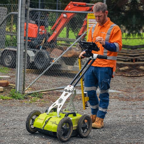
Ground Penetrating Radar Survey, or GPR Survey, is a non-destructive technique that detects and maps underground utilities, structures, and other features. The process involves sending electromagnetic waves into the ground and measuring the reflections that bounce back, providing detailed information about what lies beneath the surface.

Avoid Costly Damages

Increased
Safety

Save Time & Money

Non-Destructive Testing

High Level of Accuracy
As the construction and infrastructure industry in New Zealand grows and the use of land changes, it is essential to have a reliable and accurate method for subsurface analysis. This is where Ground Penetrating Radar (GPR) comes in. Locate Services offers a comprehensive GPR Survey service that provides accurate and detailed subsurface analysis for a variety of applications.
Ground Penetrating Radar is a non-invasive subsurface imaging technique that uses high-frequency electromagnetic waves to create images of subsurface structures. This technology has been used for a variety of applications, including geological surveys, archaeological investigations, and infrastructure analysis.

Discover hidden structures with our GPR Survey
Our team uses specialised equipment and techniques to identify and map the precise location of underground utilities, structures, and other features. This information is crucial for construction, excavation, and maintenance projects, ensuring that they are completed safely and efficiently.
Our GPR Survey services are suitable for a wide range of industries, including construction, engineering, and geology. We can help identify buried utilities, locate voids and anomalies in concrete structures, and map geological formations.